Ibeceten Fm
Type Locality and Naming
The town of Ibeceten. Type section is the low cliffs, east of Tahoua 3 km east of the Kao intersection.
References: de Lapparent de Broin et al., 1974; Dikouma, 1990; Moody & Suttcliffe, 1991; Baez & Rage, 1998.
Synonym: “Séries sénoniennes”. Equivalent(s): Together with the White Limestone Fm, it is laterally equivalent to the Doutchin-Zana Fm in the Dakoro and Ader Doutchi regions. (El Hamet, 1987).
Lithology and Thickness
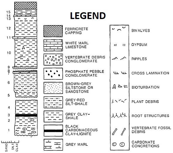
The type section exposes a sequence of shales, thin limestones, and sandy shales (Figure), which are locally fossiliferous. 60 m thick.
[Figure. Section of the Ibeceten Fm at the type section (Moody & Suttcliffe, 1991).]
Relationships and Distribution
Lower contact
Underlying unit is the White Limestone Fm
Upper contact
Overlain by the Majias Gr (Alanbanya Fm).
Regional extent
GeoJSON
Fossils
The higher levels of the formation are particularly rich in vertebrae. They correspond to the site of In Beceten, having delivered cytherid ostracods, plant debris, fish such as Lepisosteus, Amia and Polypterus, amphibians (pipids) and reptiles (pelomedusid turtles), and the crocodiles Trematochampsa taqueti (Buffetaut, 1976) and Libycosuchus. Sauropod and theropod dinosaurs, rare lizard and snake remains and fragments of dicotyledonous trees are also recorded.
Age
Depositional setting
Evidence of a marine regression during the Early Coniacian-Santonian is present throughout central and eastern Niger. The fossil content indicates a non-marine, fluvial-lacustrine environmental setting. This is supported by petrological studies of the middle part of the sequence (beds 4-9, see Figure), representing a redbed, non-marine, fluviatile sequence. The regression occurs between the T2 and T3 transgressions.
Additional Information
